
ISRIC - World Soil Information has been updating their soil property maps for the world (SoilGrids250m). Numerous improvements were implemented since publication of the `2017 version’, making this a completely new product. The first layers (spatial predictions) are available as a ‘sneak preview’ (see bottom text for details); the full version with supporting web viewer will be released around March 2020.
Major improvements include: a) direct coupling with quality-assessed and standardized soil profile (point) data provided by the ISRIC World Soil Information Service (WoSIS), b) an improved selection of covariate layers using Recursive Feature Elimination, c) quantification of uncertainties in the soil predictions, using prediction intervals, through implementation of Quantile Regression Forests, d) adoption of an improved and more realistic cross-validation procedure, and e) use of the Homolosine projection, the only projection that minimises angular and distance distortions simultaneously.
The available soil profiles (240 thousand) were spatially stratified for a robust cross-validation procedure. Based on the distribution of observations across the strata, the following basic properties were selected for global prediction: organic carbon concentration, total nitrogen content, pHwater, cation exchange capacity (measured at pH 7), soil texture (proportion of sand, silt and clay), and volume of coarse fragments. Predictions are made for six depth intervals as specified by the GlobalSoilMap project (0 - 5 cm, 5 -15 cm, 15 - 30 cm, 30 - 60 cm, 60 - 100 cm, and 100 - 200 cm). A large range of environmental covariates was compiled and edited for the 2019 release; out of this, a set of meaningful covariates was selected for predicting each soil property. This is seen as a substantial refinement to the bulk approach applied in earlier SoilGrids versions.
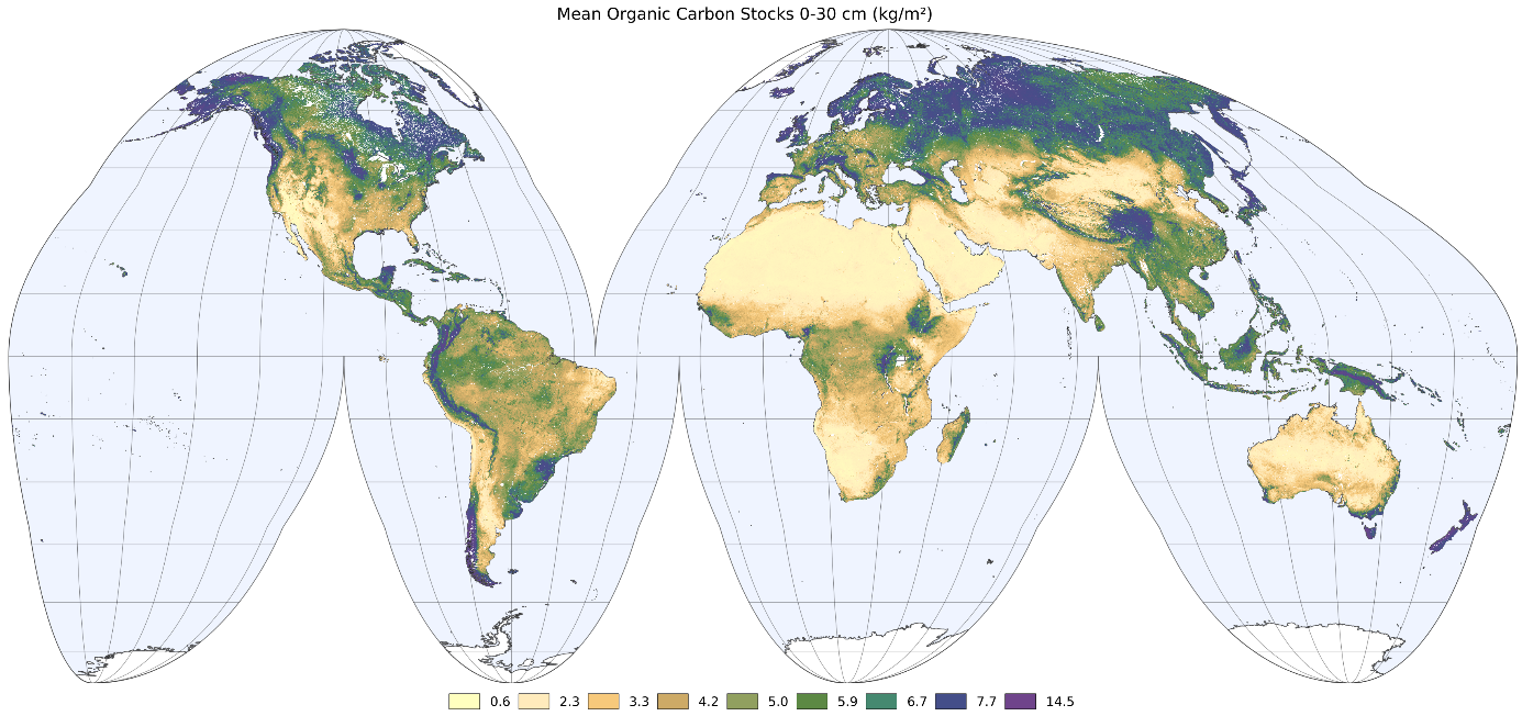
Another major innovation has been the use of the Quantiles Regression Forest algorithm, which allows for quantification of the uncertainty in the predictions. A first application of the new SoilGrids product has been to calculate and map soil carbon stocks for the world, with financial support from the EU-H2020 CIRCASA project. In early 2020, ISRIC will release a webtool with enhanced visualization, querying and download facilities, covering both the WoSIS-derived point data and respective SoilGrids250m layers, for enhanced user experience.