Tailor-made Training Courses
ISRIC serves the international community with a wide array of tailor-made courses and lectures on world soils, soil and terrain classification, soil mapping and soil information systems, as well as on the use and importance of quality-assessed soil information to underpin sustainable management of planet Earth. The courses are designed in close consultation with clients and there is much flexibility with respect to content, duration, timing and entry level.
Sections on this page: General Information | List of example course topics | Past training courses (selection)
General information
ISRIC – World Soil Information has an extensive track record in providing short and longer training courses in various soil-related subjects. These courses are defined in close cooperation with clients to ensure that the course content agrees with expectations. After an enquiry has been made, we jointly draft a course description including the timeline, programme, staffing, course materials, conditions and budget of the course. Often the courses are given at the local host, who also takes care of the logistics and recruitment of course participants. Courses almost always include hands-on activities during which course participants learn to apply the methods taught to their own case or data. Typically, participants are asked to report on their work towards the end of the course.
List of example course topics
- World soils: Introduction to soils of the world
- International soil classification - introduction to World Reference Base for Soil
- Modelling and managing uncertainty in soil maps
- Regression modelling for digital soil mapping
- Data handling in WOSIS
- Database quality control
- Compilation of Soil Data
- Soil degradation and conservation
- Soil carbon benefits
- Land evaluation and land use planning
Some courses are exclusively in the domain of soil and environmental science, while others have a strong component from geo-information science and/or statistics. Users who have limited background in these domains may get introductory lectures and computer exercises on statistics, geostatistics, GIS, R and programming in Python.
ISRIC applies reduced rates to strategic collaborative institutions and participants from ODA-listed countries.
Training on relational database development
Past training courses (selection)
Hands-on Digital Soil Mapping (DSM) Spring School Course
Date: 16 - 20 May 2022
Location: Online
The aim of this course is to introduce methods and software for the management, analysis and mapping of soil types and soil properties within the R environment for statistical computing. The course alternates between lectures and computer exercises. It covers a variety of subjects, such as geostatistics, machine learning for soil mapping, quantification of uncertainty, sampling for mapping and soil map validation.
Training course on digital soil mapping
Date: 4 - 15 February 2019
Location: Wageningen, The Netherlands
ISRIC instructed two technical experts of the Kenya Agricultural & Livestock Research Organization in digital soil mapping methods during a two-week training course. The course included the following topics: modelling spatial variability, ordinary kriging, machine learning algorithms, data preparation and map validation. The course consisted of lectures and hands-on computer exercises using local data with the statistical software R. The experts applied the methods learned to their own soil sample data set to develop a nation-wide map of soil organic carbon stocks
World Soils and their Assessment (WSA) Spring School Course
Date: 28 May - 1 June 2018
Location: Wageningen, The Netherlands
This was a course on the soils of the world and their assessment. It provided an introduction to the soils of the world and their diversity, their main forming factors, classification (according to the World Reference Base for Soil Resources 2014), and management. The course included lectures and hands-on exercises. It made use of the facilities of the World Soil Museum. The programme included a field excursion in the area around Wageningen, which has a rich diversity of landscapes and soils. In the field, several topics were addressed including: soil and landscape relations, soil formation, soil classification, field description of soils, and soil management. Furthermore, the programme included lectures and hands-on exercises on soil functions and regional planning and on soil management strategies for soil conservation and optimization of soil functions. Participants were introduced to and trained in the international classification system the World Reference Base for Soil Resources (2014, updated 2015).
Hands-on Global Digital Soil Mapping (DSM) Spring School Course
Date: 28 May - 1 June 2018
Location: Wageningen, The Netherlands
This course introduced methods and software for management, analysis and mapping of soil variables within the R environment for statistical computing. The course alternated between lectures and computer practicals and covered a variety of subjects, such as geostatistics, linear regression and machine learning for soil mapping, quantification of uncertainty and soil map validation. The course aimed at soil geographers and environmental scientists who want to learn more about the theory and practice of digital soil mapping. After this course participants were able to apply the methods learnt to their own datasets. Lecturers were experienced pedometricians and soil data analysis specialists. A number of recorded sessions from a previous Spring School can be accessed via the ISRIC YouTube channel at: http://youtube.com/c/ISRICorg.
Training on digital soil mapping
Date:27 November - 1 December 2017
Location: Vijayawada,Andhra Pradesh, India
ISRIC trained 15 professionals in land resources management, from three Indian states, in digital soil mapping methods. The training included the following topics: modelling spatial variability, ordinary kriging, machine learning algorithms, data preparation and map validation. The course consisted of lectures and hands-on computer exercises using local data with the statistical software R.
The training was organized by the Andhra Pradesh Space Applications Centre, ISRIC, CIMMYT and the Cereal Systems Initiative for South Asia, and hosted by the Andhra Pradesh Department of Agriculture with support of the Bill and Melinda Gates Foundation.
Go to the web course page (Only for course participants)
Workshop on developing Apps and Geo-services for Open Soil Data
Date: 2-4 July 2017
Location: Wageningen, the Netherlands
More information: Directly following the Pedometrics 2017 conference, ISRIC hosted an international workshop on developing apps and geo-services for open soil data (data released under an Open Data license) jointly with the LandPKS project.The event was used to give demos of the new apps and systems released in 2016 and 2017, and to discuss future directions and international collaboration. The event was joined by about 50-60 participants from several active projects developing technology for collecting, processing and serving open soil data.
More about the workshop | Pedometric conference 2017 | LandPKS project
Training 'Digital Soil Organic Carbon Mapping: towards the development of national soil organic carbon stock maps'
Date: 06- 23 Jun 2017
Location: Wageningen, the Netherlands
http://www.fao.org/global-soil-partnership/resources/events/detail/en/c/878852/
Short courses at EGU 2017 (Vienna, Austria)
- Machine Learning Algorithms for soil science data: R tutorial (27 April 2017)
Convener: Tomislav Hengl
http://meetingorganizer.copernicus.org/EGU2017/session/24389
- Accessing and using global soil data (co-organized)(28 April 2017)
Convener: Tomislav Hengl
http://meetingorganizer.copernicus.org/EGU2017/session/25193
Training on digital soil mapping
Date: 29 May - 2 June 2017
Location: Windhoek, Namibia
ISRIC trained 16 land resources management professionals from Namibia in digital soil mapping methods with the statistical software R for the purpose of developing of soil organic carbon (SOC) maps for Land Degradation Neutrality Target Setting. The training included the following topics: modelling spatial variability, ordinary kriging, regression-kriging, machine learning algorithms, data preparation, map validation and alternates between lectures and hands-on computer exercises. This training has been part of a three-week training on methods for developing baselines of Land Degradation Neutrality indicators.
ISRIC Spring School 2017(Wageningen, the Netherlands,15-19 May 2017)
Two parallel 5-day training courses on soil mapping, classification and assessment of soils.
http://www.springschool.isric.org
Training course on Digital Soil Mapping (Kathmandu/Nepal, 27-31 March 2017)
ISRIC provided a one-week introductory course on digital soil mapping for 10 professionals from the Nepalese National Agricultural Research Council, Soil Management Directorate, Tribhuvan University and CIMMYT. The course is organized by CIMMYT and hosted by ICIMOD.
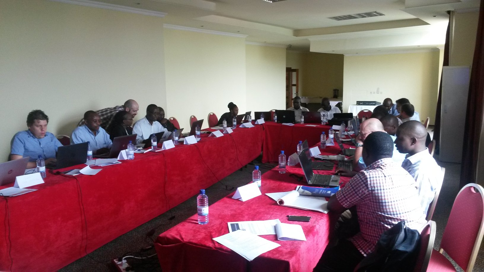
Training on digital soil mapping (Windhoek, 2-3 November 2016)

![]()
ISRIC trained 15 land resources management professionals from Namibia in digital soil mapping methods for the purpose of developing of a soil organic carbon (SOC) map of the Otjozondjupa Region. Otjozondjupa is a pilot area for Land Degradation Neutrality (LDN) Target Setting. Currently, baselines are set of four LDN indictors. The current status of SOC stock is among these.
The two-day training was part of a three-day workshop in Windhoek, Namibia on Land Degradation Assessment Methods. The training was organized by CIAT and facilitated by GIZ and the Namibian Ministry of Environment and Tourism.
Massive Open Online Course (MOOC): Sustainable Soil Management: Soil for life (May 2016)
On May 10 the first Massive Open Online Course (MOOC) dedicated to the topic of soils has started. ISRIC has been contributing to this unique learning and awareness-raising event with modules on soil functions and soil information.
If you want to learn why soil is so important, how it’s being threatened and what we can do to protect this natural resource so vital to our lives, join the free online course ‘Soil4Life’ on edX here: http://bit.ly/WURSoilx
Training 'Relational database development, population and use' (2-6 February 2015)


ISRIC trained 19 specialists from IFDC East Africa and partners in the use of a relational database for agronomic field trial data that is being developed by ISRIC for IFDC as part of the project Geospatial Farm Fertilizer Analysis. The training was held in Kigali, Rwanda from 2 until 6 February 2015. The programme alternated between lectures and computer practicals. Participants were introduced to relational database theory and SQL for querying, which has been practiced on the agronomic database. Furthermore, participants entered agronomic field trial data that they brought to the training.
Training on stakeholder interaction for RECARE project (Wageningen, 15- 19 September 2014)

Rather than suggesting soil conservation measures through a top-down approach, the RECARE (Preventing and Remediating degradation of soils in Europe through Land Care) project uses an innovative trans-disciplinary approach, actively integrating and advancing knowledge of all core stakeholders involved and aiming at a process of mutual learning.
As part of the ongoing EU project RECARE , 24 participants from across Europe gathered at Wageningen campus from 15-19 September 2014 to participate in a training on how to organise and run stakeholder workshops.
The participants themselves will be moderators soon and hold stakeholder workshops at their own case study sites to identify promising prevention, remediation and restoration measures for the local soil threat(s) identified. Rather than suggesting soil conservation measures through a top-down approach, RECARE uses an innovative trans-disciplinary approach, actively integrating and advancing knowledge of all core stakeholders involved and aiming at a process of mutual learning.
ISRIC coordinates the activity in the RECARE project that looks into the selection of measures to be implemented at the 17 case study sites in Europe from 2016 onwards. Main activities include the provision of tailor-made guidelines for each stakeholder workshop, and the organisation of training events for moderators to facilitate their task at case study site level.
As the first in a series of four, the training aimed at facilitating the work of the moderators, thus also harmonising the stakeholder-based RECARE approach across all 17 case study sites. The training was jointly organised by ISRIC – World Soil Information, Centre for Development and Environment (CDE), the Ecologic Institute and the University of Gloucestershire. The training touched upon various topics, among which: 1) the introduction of a stakeholder learning platform, 2) a field visit to the Dutch RECARE case study site at Olden-Eibergen, where innovative approaches and technologies on soil organic matter loss are being developed, 3) documentation of approaches in soil conservation measures, and 4) policies and dissemination in relation to land management.
GEOSTAT summer school 2014 (Bergen, 15-22 June 2014)
GEOSTAT is a summer school, a one-week block course, that gathers some of the main developers of the spatial analysis tools within the Open Source communities such as the R project for statistical computing, GRASS project and SAGA GIS. The main objective of GEOSTAT is to promote the use of Open Source tools, especially within the academic communities and governmental agencies. GEOSTAT Summer schools are periodically held at various locations around Europe and internationally. Participants (mainly PhD students, post-doctoral staff members and project teams) learn how to integrate these Open Source tools into their daily analysis routines. The GEOSTAT 2014 was held in Bergen (Norway) It was attended by about 60 people from some 20+ countries. It consisted of 8 parallel or single block sessions that were spread over a period of 6 days. The complete Summer school has been video recorded: Spatial modeling with environmental data | Spatial modeling with environmental data | Representing and handling spatial and spatio-temporal data in R ( part 2) | Geospatial Python.
ISRIC staff are also actively involved in developing Open Source packages and methods for the research community. Two ISRIC staff members, Gerard Heuvelink and Tomislav Hengl, participated in this summer school with three blocks/days on: using [http://plotkml.r-forge.r-project.org/|plotKML package] for visualization of spatio-temporal data and [http://gsif.r-forge.r-project.org/|GSIF package] for soil mapping, and on geostatistical methods for spatial aggregation and disaggregation.
Training session on digital soil mapping (Dar-es-Salaam, 11-13 November 2013)


The project ‘Development of a soil carbon map based on NAFORMA and non-NAFORMA datasets for the United Republic of Tanzania’ aimed to map the organic carbon content of the Tanzanian topsoil in support of the UN-REDD programme in Tanzania and the National Forest Resources Management and Assessment (NAFORMA). The project was Norwegian funded and technical support was provided by the FAO. In addition to the development of soil maps, the project had a significant capacity building component. ISRIC trained seven Tanzanian soil and environmental scientists in the theory and use of geostatistics and digital soil mapping during workshops in Wageningen and Tanzania. The project was carried in a collaborative effort with the Tanzania Forest Services Agency (Ministry of Natural Resources and Tourism), Sokoine University of Agriculture, ARI Mlingano (Ministry of Agriculture and Food Security and Cooperatives), Department of Forest and Non-Renewable Natural Resources (Ministry of Agriculture and Natural Resources Zanzibar) and African Soil Information Service (AfSIS).
The project kick-off meeting took place on 21 August 2013 in Arusha, Tanzania, hosted by AfSIS. A three-day training workshop for three Tanzanian scientists was organized at the ISRIC facilities in Wageningen, The Netherlands from 9-11 September 2013. A two-day training session, in which seven Tanzanian scientists participated, was held from 11-12 November at the facilites of the Tanzania Forest Services Agency in Dar-Es-Salaam, Tanzania. This training was followed by a one-day meeting in Dar-Es-Salaam, where the maps and mapping methodology were presented to a group of Tanzanian scientists and stakeholders.
Target depths for mapping were 0-10 cm, 10-20 cm, 20-30 cm, and 0-30 cm. The soil point dataset, with over 3,200 observations of soil organic carbon content, used was the most comprehensive dataset collected in Tanzania so far. In addition, a total of 37 environmental data layers were used as covariates. The soil organic carbon content was predicted with regression-kriging at 250 m spatial resolution.
Training workshop in digital soil mapping (Wageningen, 9-11 September 2013)
ISRIC organized a three-day workshop to train three Tanzanian scientists from Sokoine University of Agriculture and the Tanzanian Forest Services in the theory and use of digital soil mapping digital soil mapping. The workshop involved lectures and hands-on computer exercises using the open-source software R for statistical computing. Topics that were addressed during the training are introduction to R, basic statistics and geostatistics, step-by-step geostatistical analysis and modelling in R, demonstration of soil mapping with the GSIF and plotKML R-packages, validation of soil maps. The training took place in the context of the project ‘Development of a soil carbon map based on NAFORMA and non-NAFORMA datasets for the United Republic of Tanzania’. The project is funded by the FAO and carried out by ISRIC in collaboration with local Tanzanian partners and AfSIS.
Basic geostatistics with R (26-27 August 2013)
Pre-Conference Workshop Pedometrics 2013.
This workshop reviewed basic geostatistical methods and showed how these methods were implemented in the R language for statistical computing. It required no prior knowledge about geostatistics but assumed that participants were familiar with basic statistical concepts such as probability distribution, mean and variance, correlation and linear regression. The main topics addressed were: relationship between spatial variation and semivariogram, semivariogram estimation from point observations, ordinary kriging and regression kriging. The first part of the workshop was a lecture that explained the theory and illustrated it with real-world examples. The second part was a computer practical in which participants executed all steps of a basic geostatistical analysis in R using a soil pollution dataset from the Netherlands.
Spatial prediction of soil variables using 3D regression-kriging - GSIF and plotKML packages for R (26-27 August 2013)
Pre-Conference Workshop Pedometrics 2013.
This workshop continued with more advanced geostatistical methods that can be implemented in the R environment for statistical and geographical computing, namely 3D regression-kriging (soil properties) and multinomial logistic regression (soil classes). The focus of this workshop has been on using R packages for daily work, i.e. operational soil mapping. The lecturer used two packages for R (GSIF and plotKML for Google Earth) that have been developed for the purpose of automating soil mapping and that have been used for 3D mapping of key soil properties in Africa at 1 km resolution. The first part of the workshop has been a lecture that explained the design and main functionality of the GSIF package. In the second part participants used GSIF and plotKML for 3D regression-kriging of soil properties in the Ebergötzen area, Germany. This workshop also included a demonstration of how the soil grids at 1 km were derived for the African continent using the WorldGrids repository of covariates and the AfSP database that contained over 15,000 African legacy soil profiles.
Regional Soil Partnerships trained in compiling and harmonising legacy soil data
Soils provide ecosystem services and need to be managed sustainably. The Global Soil Partnership (GSP) has been initiated by the FAO to support and facilitate the development and implementation of global and regional Soil Information Systems through the establishment of Regional Soil Partnerships. The enhanced regional soil information will be used to update 1) the Harmonised World Soil Database (HWSD) and 2) complete the World Soil and Terrain databases (SOTER) and 3) produce Soil Property maps according to GlobalSoilMap.net specifications. The aim of thes initiative is to gradually enhance the quantity and quality of world soil information at various resolutions.
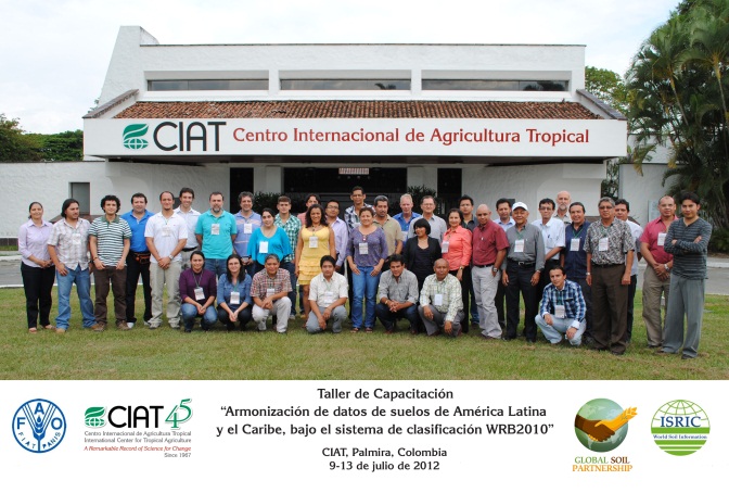
ISRIC – World Soil Information is an active partner in the GSP. In that capacity, it provides training during regional workshops, organized under the auspices of FAO/GSP, to support the compilation of harmonised soil databases, drawing on available legacy data. The first workshop was held in Cali, Colombia for the Latin America Soil Partnership (FAO/CIAT 9-13 July 2012) attended by over 30 participants. ISRIC staff also contributed to the training in Amman for the Middle East and North Africa Soil Partnership (FAO/Ministry of Agriculture of Jordan; 13-17 January 2013; 14 participants) on for the Middle East and North Africa Soil Partnership (FAO/Ministry of Agriculture of Jordan). Through these workshops, the GSP supports the development of the “Sistema de Información de Suelos de Latinoamerica Phase I and II (SISLAC)” and the “Middle East Soil Information System Phase I (MENSIS)”. The trainings focused on two subjects: 1) the compilation and standardisation of legacy soil data (both soil profiles and soil map units), and 2) the harmonisation of legacy data according to a common international classification.
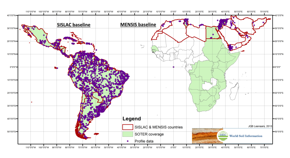
Image: Legacy soil data baseline
The sessions considered 4 major steps of data compilation: 1) entry of original data, specifying lineage and feature, attribute, method, value and the value domain/unit, 2) data standardisation according to eSOTER, 3) data collation into a SOTER-derived data model, and 4) data quality control and harmonisation according to WRB - 2010. Training materials were prepared at ISRIC by compiling legacy soil data from source databases (SOTER and WISE3) as well as on-line source reports and maps. The resulting soil database, with 2565 profiles for SISLAC and 850 profiles for MENSIS, will serve as the starting point for developing the regional soil information systems.
GEOSTAT Summer school for PhD students at IfGI, Münster (2012)
GEOSTAT is a summer school, a one-week block course, that gathers some of the main developers of the spatial analysis tools within the Open Source communities such as the R project for statistical computing, GRASS project and SAGA GIS. The main objective of GEOSTAT is to promote the use of Open Source tools, especially within the academic communities and governmental agencies. GEOSTAT Summer schools are periodically held at various locations around Europe and internationally. Participants (mainly PhD students, post-doctoral staff members and project teams) learn how to integrate these Open Source tools into their daily analysis routines.
The GEOSTAT 2012 was attended by about 60 people from some 20+ countries. It consisted of 8 parallel or single block sessions that were spread over a period of 6 days. The complete Summer school has been video recorded and the videos can be accessed via the archive.org media repository.
ISRIC staff are also actively involved in developing Open Source packages and methods for the research community. Two ISRIC staff members, Gerard Heuvelink and Tomislav Hengl have participated in this summer school with three blocks/days on: using [http://plotkml.r-forge.r-project.org/|plotKML package] for visualization of spatio-temporal data and [http://gsif.r-forge.r-project.org/|GSIF package] for soil mapping, and on geostatistical methods for spatial aggregation and disaggregation.
Uncertainty Specifications for GlobalSoilMap (Lincoln/Nebraska, August 2012)
 with bubble plot of soil pollution observations. Measurement and interpolation errors cause uncertainty in the resulting soil pollution map")
Any map suffers from measurement, classification, interpolation and generalisation errors, which may limit its usability. The GlobalSoilMap community is engaged in the production of high-resolution soil property maps for the whole world.Hence it is important to quantify the uncertainty associated with the maps produced. In order to get familiar with concepts of error, accuracy, uncertainty and spatial uncertainty, ISRIC provided a one-day course as an introduction to the GlobalSoilMap uncertainty workshop held at the NRCS National Soil Survey Center in Lincoln, Nebraska (USA) from 27 to 30 August, 2012.
The course started with exploring and comparing error, uncertainty and accuracy and explaining how these concepts can be defined in statistical terms by means of probability distributions. Next it extended the probabilistic model of uncertainty to variables that vary in space, in which case use is made of geostatistics. It also looked at how these modelling approaches may be incorporated in digital soil mapping.
The course was attended by about 30 people, mainly from the USA and Australia, but also from Canada, New Zealand and France. It provided a very useful introduction to the main theme of the workshop and helped formulate uncertainty-related details of the specifications of the GlobalSoilMap products.
Hands-on-software training at the Australian National University (April 2011)
Universities are showing increasing interest in using open-source tools to process environmental data. ISRIC promotes the use of tools such as Open Source GIS software and R, the open source environment for statistical computing. In April 2011 ISRIC senior researcher Tomislav Hengl moderated a 5-day R + OS GIS training course at the Australian National University in Canberra.
The program focused on using free and open-source software for geo-statistical mapping, on-line databases and web applications. The participants came from all over Australia and New Zealand and had wide range of backgrounds including biology, soil science, agronomy and geological exploration. Upon completion of the course, the participants were able to install the combination of the software packages, import and export their data sets in R + OS GIS, and run various types of spatial analysis. The course was run jointly with Dylan Beaudette National Resource Conservation Service (VS) and Pierre Roudier from the Landcare Research in New Zealand.
Soils science lectures for hydrologist and environmental engineers at UNESCO-IHE
Knowledge of the soil helps hydrologists to make adequate assessments of ground water recharge, river flow response to rainfall, and improve assessments of impacts of land use and industry on quality of (water in) soils, rivers and groundwater. Hydrologists and environmental engineers therefore have a need for basic soil knowledge and require skills to assess and interpret soil information for hydrological and environmental (impact) assessments. It is therefore that ISRIC provides soil science lectures to students of IHE-UNESCO for Water Education in Delft, for more than 10 years now.
The lectures include subjects on soil types and their spatial variation, soil chemical and physical properties, soil degradation and conservation, and the use and interpretation of soil information. The soil lectures are given in the module “Fundamental Processes in Environmental Science” of the institute and include lectures at IHE in Delft, a lecture on soils of the world in the World Soil Museum and a field trip to Limburg.
Training for Digital Soil Mapping (Ispra, 1-3 Feb 2012)
 in 2011")
Web-based digital soil maps help European policymakers and scientists to find the soil data they need for their models or decisions in fields such as land management and biodiversity conservation. The EU's Institute for Environment and Sustainability in Ispra, Italy, is the focal point for soil information at the European level. To familiarize its junior soil scientists various methods needed to bring soil data into digital soil maps ISRIC provided an on-site training course in Digital Soil Mapping (DSM) between 23 - 27 January 2012.
The goal of the training was that participants would able to reproduce different methods and approaches in proprietary and open-source software environments. The focus was on the different steps in DSM workflows, addressing data input quality and prediction uncertainty. Course participants worked on examples in the programming languages Python and ArcGIS, as well as the Open Source R-project with its many libraries
The course was enthusiastically received, and ISRIC and the IES are planning further cooperation on European wide digital soil mapping under the agreement between ISRIC and the European Commission Joint Research Centre, of which IES is an institute.
Assistance to Land Resources Assessment in Cambodia (May 2005 - March 2006)
With funding from GTZ, ISRIC assisted the national Land Resources Assessment team in Cambodia to compile and assess national land resources in terms of their suitability for settlement of small-holders in so-called social concessions [May 2005 – March 2006].
The assistance included on-the-job training in the creation of a national Soil and Terrain database (SOTER) at a scale of 1:500 000.