Information about soil nutrient contents is key for explaining measured crop responses to soil fertility management practices and for updating and upscaling of soil fertility management recommendations. This project, implemented primarily upon request of the Netherlands Environmental Assessment Agency,(PBL), produced soil nutrient maps of Sub-Saharan Africa with the aim to contribute to increasing agricultural sustainable productivity.
Results include spatial predictions of soil nutriënt contents (macro-, meso- and micronutriënts) across Sub-Saharan Africa at a spatial resolution of 250 m for 0–30 cm. Model training was run using soil samples from over 59,000 point locations and an extensive stack of covariates including remote sensing covariates, landform, lithologic and land cover layers (maps). Spatial predictions were made using an ensemble model from the machine learning algorithms random forest and gradient boosting, implemented in R packages ranger and xgboost. The results of cross-validation showed that apart from extractable S and P, significant models can be produced for the targeted nutrients (R-square between 40–85 %). A limiting factor for mapping nutrients using the point data available for Africa is the high spatial clustering of the sample locations, following the AfSIS design, causing many countries and land cover / land use groups being unrepresented.
This work presents a systematic follow up to maps published in Hengl et al. (2015); R code used to generate the revised predictions is available via the github repository.
The work should be cited as follows:
-
Hengl, T., Leenaars, J.G.B., Shepherd, K.D., Walsh, M.G, Heuvelink, G.B.M., Mamo, T. et al. (2017) Soil nutrient maps of Sub-Saharan Africa: assessment of soil nutrient content at 250 m spatial resolution using machine learning. Nutrient Cycling in Agroecosystems 109: 77-102. DOI: 10.1007/s10705-017-9870-x.
Training points (soil data) used to generate these maps were obtained from:
-
AfSIS (Africa Soil Information Service): 18,000 samples (0-20-50 cm) in SSA (from 9,600 point locations in 60 sentinel sites of 10 by 10 km),
-
AfSIS (Africa Soil Information Service): 60,000 samples (0-x cm) in SSA compiled for AfSIS in the Africa Soil Profiles Database (from 18,500 soil profile point locations in 40 countries with on average four depth intervals to on average 125 cm depth); analysis by a variety of laboratory methods,
-
EthioSIS (Ethiopia Soil Information Service): 15,000 samples (0-20 cm) in Ethiopia
-
GhaSIS (Ghana Soil Information Service): samples (0-20 cm) in Ghana
-
NiSIS (Nigeria Soil Information Service): 3,000 samples (0-20-50 cm) in Nigeria
-
IFDC (International Fertilizer Development Center): 3,500 samples (0-20 cm) in Uganda, Rwanda and Burundi
-
One Acre Fund: 2,400 samples (0-20 cm) in Uganda and Kenya;
-
University of California, Davis: 1,800 samples (0-20 cm) in Kenya;
-
VitalSigns: 1,374 samples (0-20 cm) in Ghana, Rwanda, Tanzania and Uganda.
Download maps
All maps are available for download and via Web Coverage Service at https://data.isric.org under the Open Database License (ODbl) v1.0 and according to the ISRIC data-policy.
|
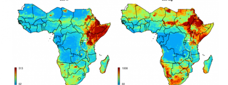
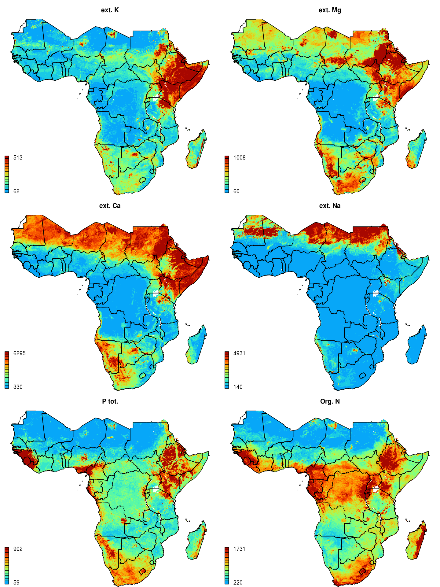
Predicted soil macro-nutrients for SubSaharan Africa(in ppm).(click to enlarge) |
The maps can also be downloaded at:
-
extractable phosphorus (P) by Mehlich 3 (pp100m; divide value by 100 to obtain a value in ppm),
-
extractable sodium (Na) by Mehlich 3 (ppm), is not a nutriënt.
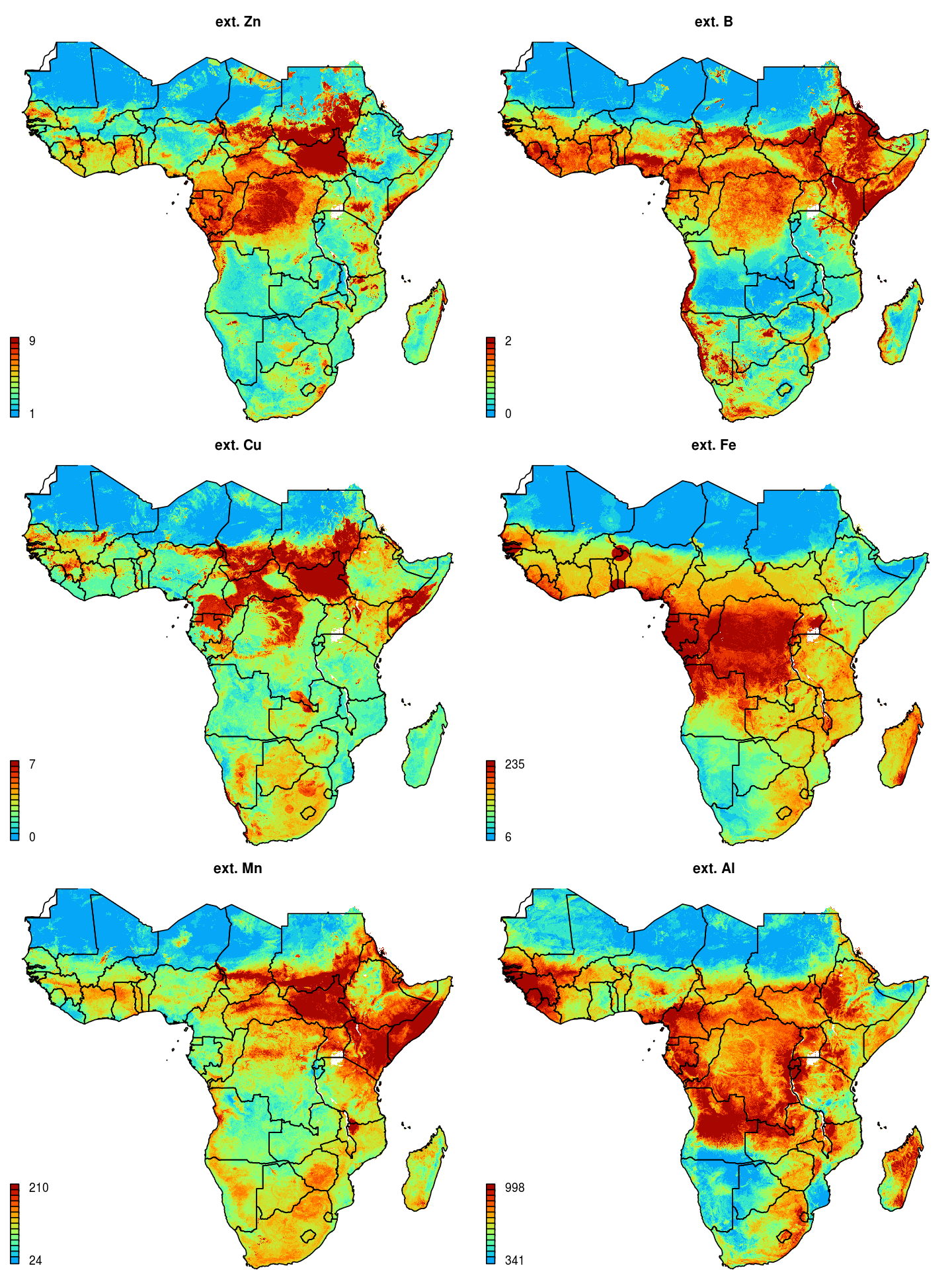
Predicted soil micro-nutrients for SubSaharan Africa (in ppm). (click to enlarge)
|
-
extractable aluminium (Al) by Mehlich 3 (ppm), is not a nutrient
-
extractable boron (B) by Mehlich 3 (pp100m; divide value by 100 to obtain a value in ppm),
-
extractable copper (Cu) by Mehlich 3 (pp100m; divide value by 100 to obtain a value in ppm),
-
extractable manganese (Mn) by Mehlich 3 (ppm; divide value by 100 to obtain a value in ppm),
-
extractable zinc (Zn) by Mehlich 3 (pp100m).
These above maps are spatial predictions based on using Machine Learning algorithms and best available data; as such they are unlikley to be deviod of errors and artifacts. We aim at updating these maps once new training / point soil data are shared with us.
Acknowledgements
This study has been conducted primarily upon request of the Netherlands Environmental Assessment Agency (PBL). Acknowledgments are due to PBL and to the various projects and organizations that shared soil data for this specific study, including: the AfSIS project (Africa Soil Information Service), funded by the Bill and Melinda Gates Foundation (BMGF) and the Alliance for a Green Revolution in Africa (AGRA), which collected soil test data from sentinel sites across SSA and more recently from sites in Ethiopia, Ghana and Nigeria, as funded primarily by the Ethiopian government, the Ghanaian government and OCP-Africa, respectively, in collaboration with EthioSIS (ATA: Agricultural Transformation Agency), GhaSIS (CSIR-SRI: Soil Research Institute of the Counsil for Scientific and Industrial Research) and NiSIS (IITA: International Institute for Tropical Agriculture). Also funded by BMGF is the Vital Signs project with interventions in Ghana, Rwanda, Tanzania and Uganda. Funded by the Netherlands government are the CASCAPE project, also contributing to EthioSIS, which collected soil profile data from Ethiopia and projects of the International Fertilizer Development Center (IFDC) which collected soil data in collaboration with the governments of Burundi, Rwanda and Uganda. The One Acre Fund made the collection of soil samples possible in Rwanda and Kenya and the University of California, Davis, in Kenya.