New paper: Multivariate random forest for digital soil mapping
A new open access paper from ISRIC-supported PhD researcher Stephan van der Westhuizen and co-authors demonstrates the use of multivariate random forest modelling in digital soil mapping.
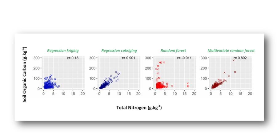
The paper, published in February 2023 in Geoderma, showcases the methodology for using multivariate random forest to model and simulate multiple soil properties simultaneously, and thereby retaining the relationship between the soil properties. The paper used a case study of soil organic carbon and total nitrogen and showed how the carbon-nitrogen relationship was retained when modelling these soil properties with multivariate random forest. The retention of relationships between soil properties in the output of the modelling means that derivatives made from the maps using this method can also rely on that relationship.
Full citation: Stephan van der Westhuizen, Gerard B.M. Heuvelink, David P. Hofmeyr. 2023. Multivariate random forest for digital soil mapping. Geoderma. https://doi.org/10.1016/j.geoderma.2021.115458.
“Machine learning is not new for soil mapping, but there are certain key problems to tackle to improve our use of it, and this is the first study to show how multivariate random forest modelling can be applied to soil mapping,” explained Stephan. His PhD-research focusses on how to enhance the use of machine learning for digital soil mapping.
Access the paper here: https://doi.org/10.1016/j.geoderma.2023.116365
“ISRIC wants to be at the forefront of developments in digital soil mapping and this publication is an excellent example of that. Stephan’s work is particularly relevant for digital soil assessments, where multiple soil properties are combined to evaluate soil functions and soil threats,” said ISRIC – World Soil Information senior researcher and paper co-author Gerard Heuvelink, who also holds the title special professor in pedometrics and digital soil mapping at Wageningen University.
Stephan is a lecturer at Stellenbosch University in South Africa and is completing his PhD with ISRIC and the Soil Geography and Landscape Group at Wageningen University. His co-authors on the paper are Gerard Heuvelink and David Hofmeyr, who is a senior lecturer in statistics and actuarial science at Stellenbosch University. They are also the co-supervisors of Stephan’s PhD research, as is Laura Poggio from ISRIC.
In 2022, Stephan spent six months in Wageningen with the support of the Climate, Food and Farming, Global Research Alliance Development Scholarships (CLIFF - GRADS) program. CLIFF – GRADS is a program of the CGIAR Research Program on Low-Emission Food Systems.

“The fellowship allowed me to have a period where I could spend all my time on my PhD-research, and in an environment where everyone is working in the same domain, that helped me a lot,” said Stephan.
This research was also supported with funding from the Thuthuka project of the National Research Foundation of South Africa (grant number: 129856).